Thursday, June 8, 2017
OODNADATTA TRACK
We
left Cooper Pedy & drove to William Creek which was 186km. The
dirt road was in good order and it was only the last 20kms that was a lot of corrugations. We past sand lakes and saw a lot
of salt pans, the dog fence travelled with us for more than 30kms. We
booked into a campsite which was non powered and cost $28 per night. We
met a couple who were travelling up to Timber Creek where she is a
nurse and working with the Aboriginals. It turned out she lived just
around the corner from me in my past life and knew people who I (Robyn)
knew it was so sureal.
Dog Fence Australia holds many world records, including the world's longest fence, the dingo fence. At 5,531 km, the dingo barrier fence stretches from eastern Queensland all the way to the South Australian coastline
We
left William Creek heading for Marree, no rush, must say we didn't rush
anyday. We travelled past ruins of fettlers cottages, and rail
memrobillia as we were following the old Ghan track. Other ruins were
from when the Overland Telegraph Line was through up to Darwin.
The
old Ghan line was also following the springs to help with the water for
the steam trains. This area has a lot of history, not only being remote
but you wouldn't think it as there were more people on the track than I
ever thought possible, a lot of caravans, even which were not off roaders. Before
we left William Creek I purchased a book at the pub which helped us and
kept us amused with the antics of the explorers & pastoralists.
Coward Springs is rather a nice place to have a warm bath
(especially if you haven't showered for a few days). We ended our first
day at Marree Pub with a free camp next to it. You do not have to go
into the pub to purchase anything but a good free camp, but, how
could you not when it was right next door. A little history about
Marree, it was first discovered as a permanent springs during John
McDoual Start's second expedition into the interior in 1859. The
development of the South Australian outback it seems Marree is tied
closely to the use of camels for outback travelling & settlement was
a major staging posts for the Afghan & Indian cameleers. In the
heyday up to 100 strings of camels working. A string could be up to 70
camels. This was crucial to the building of the Overland Telegraph &
Old Ghan Raiway Lines.
PHOTOS:
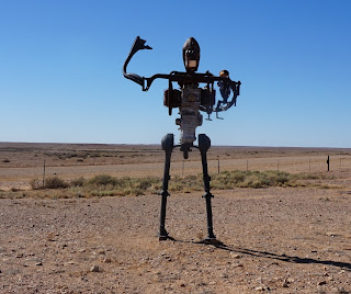
3 of the statues which are seen Alberrie Statue Park, the head of the dog is made of a old Chrysler.
Beresford Springs 
Beresford Siding Dam
The next few photos are of Lake Eyre.
Coward Springs
The inside of the property.
We arrived at the iconic Marree Hotel.
We had a lovely meal at the Marree Hotel
and the average may be a little more expensive ie large parmagiana cost
$25 when we mostly pay $18-$20. The bar costs are good. A glass of
wine is $6.
We took a day drive to Lyndhurst, Farina & the ochre cliffs. Five
kilometres north of Lyndhurst on the Oodnadatta Track in the South
Australian Outback you’ll see a tyre beside the road with the words
‘Ochre Cliffs’ crudely written on it.
Follow
the side-road for a few kilometres and you’ll suddenly see an open
ochre quarry containing spectacular red, brown, yellow and white ochre cliffs
(an exposure of saprolite) mined for thousands of years by the local Aboriginal people.
Lyndhurst is a very small town with a pub & roadhouse.
We had heard of the "Back of Beyond Bakery" we read about it before we left home The Bakery Baking Today sign at the Farina turn-off in the middle of the Outback just HAD to be too good to be true we travelled into Farina ruins, the bread, pies & cream buns are beautiful some of the best bread we have ever tasted.
their bread.
Farina is located within the Lake Eyre Basin, 26 km north of Lyndhurst and 55 km south of Marree. The town is no longer inhabited, but a small group is restoring parts of Farina to reflect its past and ensure that it is retained in the history of Australia's outback. The eerie town of Farina sits on the edge of the desert and was settled in 1878 by optimistic farmers who thought it was the perfect location to grow wheat and barley. Unfortunately, they were very mistaken. The regular rainfall was nowhere near enough to sustain the crops and despite being located on the former alignment of the Ghan railway, with two hotels, two breweries, and a bakery, it fell into decline in the mid-1900s and is now uninhabited. Every year from mid May to mid July they open the bakery with the help of volunteers & two bakers using the underground ovens. All the money made is used to help restore the old ruins by repointing them as above. If you wish to volunteer, then contact them through the internet.
Our
trip from Marree to Oodnadatta where we backtracked to William Creek,
then it was interesting as we found more ruins on the way. We spend on
night camping at Old Peak Telegraph Station ruins where it was just us
& nature, + a few camels which we heard overnight, also owls and the
silence. Had a great fire as it was so very cold we needed to warm up
before entering our swags.

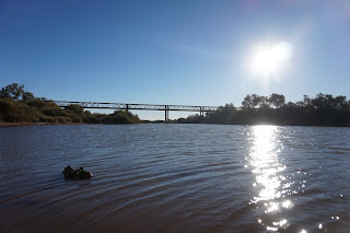
Our next camping stop was at Alegbuckina Bridge & waterhole on
the Neals river where we camped directly under the bridge and during
the night heard it come alive with all of its creaks and groans
(expanding/contracting) it sounds like I feel in the morning!! Some
facts about the bridge is it still stands as the longest single span
bridge in South Australia. Half kilometer long with a cost of over
sixty thousand pounds & opened to rail traffic on 6th January 1892.
Algebuckina wasn't just about the railway, it also had a history of
mining for gold. As you drive into the waterhole/bridge a rusting
/crumpled old vehicle can be noticed, yes there is a story to this, as
it goes with the river in flood the daring driver decided in his
infinite wisdom to drive over the bridge, unfortunatley he nearly made
it all the way across but met a work gang's train reversing southward.
The night before I had tossed out two pieces of toast and when we were
around the campfire in the morning he and his family came out to eat it
beside where we were sitting.
We
met a lovely couple who we had a happy hour with the night before &
once again met them the next morning as we were leaving, they were
going to stay a few nights. It was a great Free Camp
Off we go on our penultimate stage of our journey staying at Oodnadatta for the night a mere 70kms up the road.
I was facinated with the stoney desert, just everywhere you looked was brown stones.
Whilst travelling to Oodnadatta we visit more ruins of Mt Dutton fettlers cottages.
We
roll into Oodnadatta with me driving, the first thing we see is a
bloody pink building and that is the iconic Oodnadatta Roadhouse, since
not eating breakfast we sat down to eat lunch.
Tonight
we were going to "Glamp It" I booked a night in a cabin at the cost of
$120 for the night. Something we learned about Oodnadatta was they make
wonderful huge hamburgers, the beef patty is rather large &
delicious apparently they are well known for it. The staff very
friendly, they told us that the hotel was closed and had been for
several months as they cannot get a publican to run the place. This is
owned by the Aboriginal Land Council. The roadhouse has takeaway
alcohol all the wine is $25 per bottle, the beer is more expensive to
purchase here than in Coober Pedy. Diesel was $1.85 per litre.
After
a night of luxury we had to leave early the next morning as they wanted
us out by 9am, we are heading to the painted desert with me driving (I
was liking the drive "up an old dirt road" Lee Kernaghan song). At this point I must confess that Drew did most of the driving.
At
this stage we are heading south-west of Oodnadatta we started our 90km
trek. Apart from a few corrugations here and there it was a good road
heading out - we did pass two graders closer to Acaringa Station.
There
lies our wonderful, exciting & awesome trip over the Oodnadatta
track. Loved it so much thinking of doing it again next year with our
4x4 club.


No comments:
Post a Comment
Thank you for your comment. It is awaiting approval.